Validated Targeting and Resource Prediction Method for Mineral Exploration
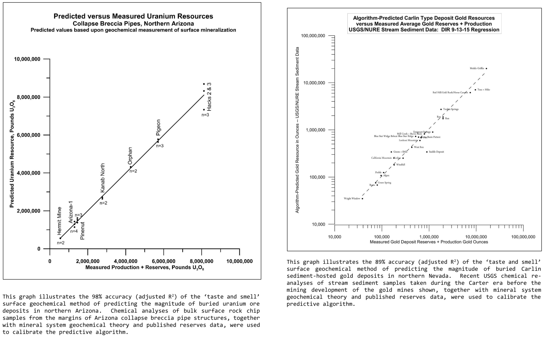
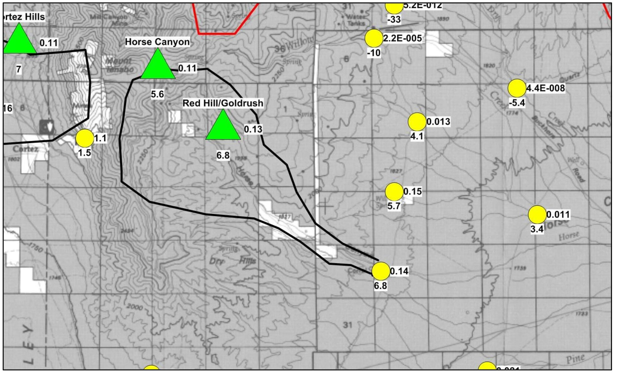
Case studies demonstrate 98% R-squared accuracy for uranium, and 89% R-squared accuracy for gold in predictions of magnitude of buried ore resources from surface sample geochemical data.
Download the Technical Summary (PDF)
Peer-Reviewed Validation
| Use of Surface Lithogeochemistry to Estimate Magnitude of Blind Uranium Mineralization in Northern Arizona Collapse Breccia Pipes | Apparent MVT Lead Mineralization as Defined by a Linear Regression Sulfate Reduction Geochemical Model Calculated from Lead Production and Reserves Records, and from NURE Program Stream Sediment Geochemical Analyses |
|
An AIPG-published description and detailed explanation of the new geochemically- and mineral systems theory-based exploration targeting and resource-predictive method as it applies to the buried uranium ore deposits of northern Arizona. |
An AIPG-published description and general explanation of the new geochemically- and mineral systems theory-based exploration targeting and resource-predictive method as it applies to the buried Pb-Zn ore deposits of southeast Missouri. |
Some Mineral Exploration Practitioner Comments
| Dr. C. Jay
Hodgson, former Chief Geologist, Barrick Gold, and Professor of Mineral Deposits Geology, Queens University: |
Mr. Alan Levy, Principal, Alan Levy and Associates : |
| Larry, Many thanks for sending me this brilliant paper and the attached maps from your work on Carlin-type deposits in Nevada. This is one of the most impressive innovations in applied exploration technology I have ever seen. I hope you plan to publish the geochemical "equations" you have defined for targeting Carlin and LS epithermal deposits, but if you don't, I'm totally sympathetic: you deserve to make your fortune by using your research to find deposits, or to have an equity stake in discoveries made by others who use your techniques! A couple of questions: 1. Would you be interested in consulting for mineral exploration companies who would like to use the technique you describe? 2. Have you considered tackling the problem of Witwatersrand deposits, which almost certainly formed in a manner similar to roll-front and breccia-hosted Cu and U deposits, as well as Red Bed Cu deposits. Now if we could find another Wits Basin among the many similar molasse basins of the world... And one suggestion: why don't you see if you Carlin model indicates if Barney's Canyon and Melco are (or are not) "real" Carlin deposits?" Cheers, Jay Hodgson |
Larry: Perhaps you know the drill ... get a probably scam email, so don't click on any of the links. Then read the text and edge over to the side of "maybe it's legit." Then download the pdf and read that. Then make Excel sheet of the values provided in Table II, "Index Cases." Add the coefficients for the linear equation and verify that I can get the predicted resource pounds. Make a few graphs. In other words, definitely fascinated by your work! My next goal is to see if I can duplicate the coefficients. I see your references, but not interested in buying the books, so I guess I have to hit my local college's library (UCLA). ...unless you have the necessary pages as a pdf, for which I would be thankful. I looked at your photograph on linked in, and see that you are an old geezer ..... hey, just like me. I've done a bit of uranium exploration in Nevada, Precambrian on the U.S. East Coast, redox concept in Devonian redbeds of Pennsylvania. Etc. Lots of etc! What I am more interested though, is in the use of your methodolgy for porphyry deposits. I once found an area in southeastern Alaska that had propyllitic alteration, quartz-sericite-pyr alteration, bits of Pb Zn pyr mineralization and occasional clotty moly. The question was, deep and possibly strong system, or just a very weak system. So, if I have not said so already, thanks for sending this stuff my way. It is a step beyond my old days of making log normal plots to see if there was a mineralized normal distribution, as well as a background normal distribution. Regards, Alan Levy |
The Method in Brief: Working from the Known to the Unknown
This practical mineral systems approach to mineral exploration maximizes the accuracy of theoretical mineral system models and subsequent exploration work by identifying and measuring only the necessary and sufficient surface geochemical expressions ('taste and smell') of the original ore-forming processes. This yields a direct, quantitative estimation of -- among other things -- subsurface ore resource magnitude. In the two cases to date that the necessary data were available for the ore deposits of particular mineral provinces, this same approach also closely and usefully estimates depth to top of mineralization (Arizona uranium-mineralized collapse breccia pipes) and average expected mine ore grade (Carlin-type sediment-hosted gold deposits).
It is critical to understand that this method stands on the shoulders of the previous conventional exploration and mining work of the industry. Without the previous orebody discoveries and the data revealed by those discoveries and mine developments, this new exploration methodology could not be made to work. Application of geochemical mineral systems theory is especially important as it serves to drastically reduce the number of known and well-examined mineral deposits required for valid causal linear regression of the primary geochemical system factors producing the orebodies sought. In the northern Arizona uranium-mineralized collapse breccia pipe case, for example, only seven (7) known and well-studied uranium ore deposits were required to generate accurate resource and depth-to-mineralization predictive causal algorithms for this deposit type and its containing northern Arizona mineral province.
Mineral System Process -> Creates Observable Proxy (Geochemical Leakage Halo) -> Measurement & Regression -> Predictive Estimates of Deposit Locations, Ore Quality, Reserves and Depths
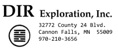
The reconnaissance stream sediment geochemical sample map below serves as a good example of the ability of the new applied exploration technology to 'de-risk' exploration expenditures in time and money -- and therefore to maximize eventual mining returns.
 | A retrospective map demonstration of the ability of the new applied exploration technology to 'de-risk' exploration expenditures in time and money -- and to maximize eventual mining returns: A geochemical reconnaissance stream sediment sample map of the ~7 square mile drainage cell area in Nevada containing Barrick's Barrick’s 2004 Red Hill/Goldrush Carlin-type gold deposit discovery. The yellow circles represent the locations of stream sediment samples taken during the US 1975-1980 NURE geochemical program -- at least 24 years before Barrick made its gold deposit discovery. Numbers on the bottom of each yellow stream sediment location symbol are the log10 gold resource troy ounces predicted using the method under discussion, while the numbers to the right are the similarly predicted average ore grades in troy oz/ton. Green triangles are the locations of the known gold deposits in the area, with log10 resources below and average ore grades to the right. Note: 1) the close match between Red Hill/Goldrush reserves and grade figures and those calculated from the NURE sample taken at the end of the Horse Canyon wash; and 2) the much lower calculated resource and grade figures from stream sediment samples peripheral to the location of the discovery stream sediment sample. |
Download the Technical Summary (PDF)
Summary for Exploration Managers, Strategic Partners, and Other Investors in Mineral Properties
This methodology is a tool for directly and very significantly de-risking greenfields and brownfields exploration, and therefore objectively justifying and prioritizing joint venture and other mineral property expenditures. In addition, the tool makes possible discovery of additional ore deposits in mineral provinces long explored by conventional methods.
Propose a Confidential Evaluation of Your Data: ldturner@dirxploration.com
Biographical Sketch and Contact Information
Lawrence (Larry) D. Turner is the exploration geochemist and geologist behind the development of this method, with decades of focused work on geochemical processes and exploration targeting (and a numeracy-increasing MS degree in mineral economics from the Colorado School of Mines). His work cited here is published in The Professional Geologist by the American Institute of Professional Geologists.
Contact:
email: ldturner@dirxploration.com; website: www.dirxploration.com ; LinkedIn: https://www.linkedin.com/in/larry-turner/
Privacy Note: Information that you provide through contact with DIR or Larry Turner after visiting this website is used solely to respond to your inquiry and is not shared with any third parties.